The Government of the Hong Kong Special Administrative Region
Development Bureau
Join us for CSDI Awards 2025 Sharing Session, where talented Open Category finalists showcasing their innovative uses of spatial data to the development of the Northern Metropolis. We encourage all participants to engage with these finalists, embrace new opportunities, unlock new business potential.
| Date: |
27 September 2025 |
| Time: |
10:00 – 12:00 (Registration starts at 09:30) |
| Venue: |
Geospatial Lab (Units 915-918, 9/F, Tower 1, Millennium City 1, 388 Kwun Tong Road, Kwun Tong, Kowloon) |
| Agenda: |
|
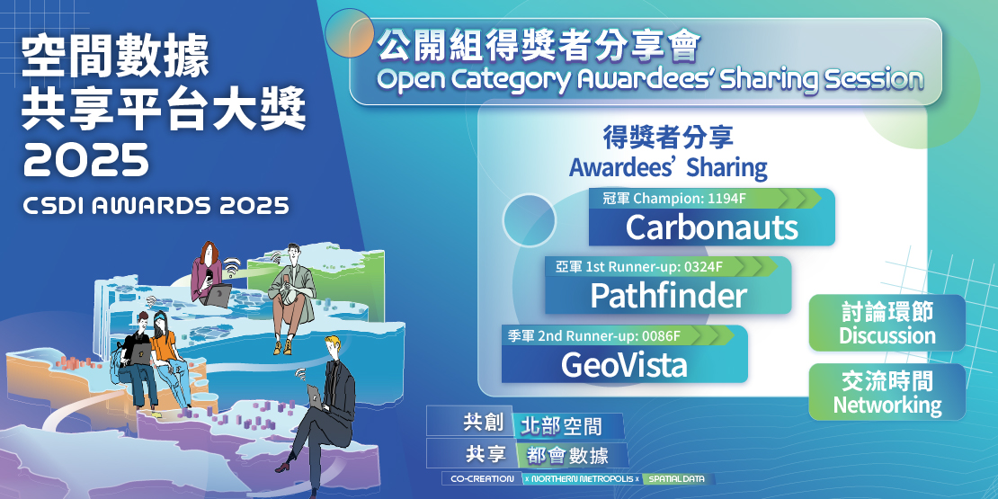
Champion: Carbonauts - Carbonopolis
Members:
PEI Chenya
SHAN Yan
DENG Wenqian
WU Kunheng
LI Zhihao
ZHENG Jiacheng
Introduction:
Carbon Monopoly envisions net-zero development in Northern Metropolitan, using San Tin as an example to quantify the impact of development on the natural environment. It offers a comprehensive carbon management solution through a "game" and a "data platform." The game design encourages the public to rationally consider the relationship between development and the environment, and to understand how technology can reduce environmental impacts. The carbon data platform emphasizes monitoring carbon emissions from land development, construction, and operation perspectives, aiming for sustainable development in Northern Metropolitan.
1st Runner-up: Pathfinder - Co-creating the future of SAFE Low Altitude Economy (LAE) in the Northern Metropolis
Members:
CHAN Chun Kit Jacky
KAN Wing Chung
MA Chun Kit Vincent
CHOI Ming Tak
CHUNG Siu Kay Ken
TANG Tin
Introduction:
"OpenGAIN" co-creates a secure Low-Altitude Economy future for Hong Kong's Northern Metropolis by leveraging 30 integrated data streams—including real-time IoT feeds, GIS analytics, and AI—to resolve critical pain points. The platform enables shared flight planning, delivers real-time 3D airspace intelligence, performs spatial analysis of takeoff sites, incorporates SORA ground risk mapping, and provides AI-powered congestion alerts. This comprehensive approach empowers citizens to fly safely, allows the government to govern airspace dynamically, enables precision insurance underwriting, accelerates emergency drone deployment, ensures reliable logistics delivery, and safeguards migratory bird eco-corridors for balanced ecological coexistence
2nd Runner-up: GeoVista - BGI Insight Hub
Members:
CHEUNG Wing Ki
CHAU Hoi Ching
Introduction:
BGI Insight Hub is a map-centric web application designed to promote flood resilience in Northern Metropolis (NM) to general public. By leveraging ArcGIS, it visualizes site suitability for blue-green infrastructure (BGI), offers flood simulations in NM, and provides educational infographics to raise public awareness. It empowers urban planners, residents, and agencies with data-driven tools for sustainable urban development. Using spatial data like terrain, drainage, and rainfall, it optimizes BGI placement, reduces flooding, and preserves ecosystems, fostering a flood resilient and livable NM.
Please contact the Geospatial Lab via 3708 7260, WhatsApp 9187 2916 or email services@csdigeolab.gov.hk
Contact Info
Telephone: 3708 7260
WhatsApp : 9187 2916
Email: services@csdigeolab.gov.hk
Address
Opening Hours
Monday to Saturday
09:30 am - 1:00 pm
2:15 pm - 5:30 pm
Closed on Sundays and Public Holidays
Follow Us

Links
